

All Roads

The Integrated Transportation Command and Dispatch Platform (TOCC), built around traffic operation monitoring scenarios, focuses on business processes such as road network monitoring, transportation safety, passenger travel, transport hubs, and public transit. It integrates multiple technologies—including big data, unified communications, collaborative control, and perception—deeply explores business scenarios, extracts data value, closes operational gaps, and drives transportation management efficiency through data. The platform consolidates operational data from multiple business domains, providing comprehensive services such as monitoring, analytical decision-making, industry supervision, and emergency support. Built on a data middle-platform foundation, it leverages data to empower key transportation indicators, monitoring, and decision-making, establishes a unified transportation data labeling system and intelligence center, enables business collaboration and application innovation, and promotes modernization and intelligence in transportation industry governance.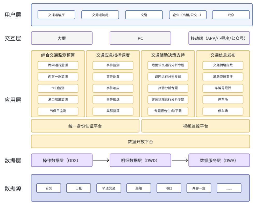
System Architecture Diagram

1. More Standardized Data Governance:
The platform applies big data and artificial intelligence technologies, integrating AI knowledge graphs and human–computer interaction to improve data quality, break down cross-industry and cross-department data sharing barriers, and enhance comprehensive data utilization, providing better services for government decision-making, industry supervision, enterprise operations, and public travel.
2. Traffic Situational Visualization and Control:
Based on AI and big data technologies, the platform constructs an integrated monitoring system through indicator monitoring, GIS display, and video surveillance linkage analysis, improving monitoring efficiency.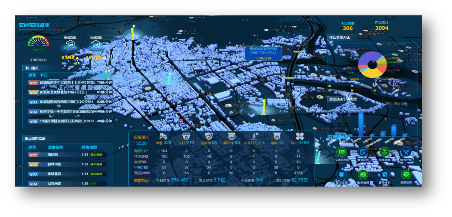
3. Precise Anomaly Event Detection:
Using data mining and AI analysis, the platform monitors and provides early warnings across multiple industry scenarios, promptly issues alert information, and establishes a comprehensive traffic monitoring and early-warning system to prevent incidents before they occur.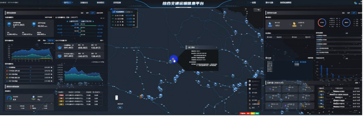
4. Clear Emergency Resource Management:
Emergency resources are visualized, with monitoring of resources and warning information around incident locations. The platform collects incident information, displays multi-regional event distribution, personnel and materials, and handling progress, enabling unified visual management of emergency resources. This ensures on-site data can be uploaded, dispatch commands can be executed, and command operations are fully visible.
5. More Scientific Traffic Management Decision-Making:
Based on comprehensive traffic data collection and in-depth information integration, mining, and refinement, the platform quantifies and visually evaluates traffic operation status, providing support for comprehensive transportation planning and management decision-making.
6. More Convenient Public Travel:
Through multiple channels—website, information boards, apps, WeChat, and Weibo—the platform creates a unified traffic information service portal, offering refined, personalized, and high-quality traffic information services, thereby enhancing the public travel experience.

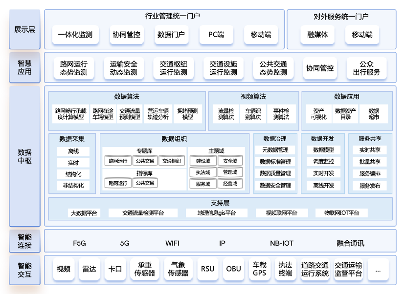
The Integrated Transportation Monitoring Architecture consists of five layers: Presentation Layer, Intelligent Applications, Data Hub, Intelligent Connectivity, and Intelligent Interaction.
1. Presentation Layer: Monitoring content is displayed through two types of portals: the unified industry management portal and the unified external service portal. The unified industry management portal includes integrated monitoring, collaborative control, data portal, PC interface, and mobile interface. The unified external service portal includes media integration and mobile interfaces.
2. Intelligent Applications: Integrated transportation monitoring comprises sub-functions including road network operation status monitoring, transportation safety dynamic monitoring, transport hub operation monitoring, traffic facility operation monitoring, public transit situational monitoring, collaborative control, and public travel services.
3. Data Hub: Mainly includes: Data algorithms: road network capacity calculation model, en-route vehicle model, traffic flow prediction model, operational vehicle trajectory analysis, congestion prediction model; Video algorithms: traffic flow detection algorithm, vehicle recognition algorithm, event detection algorithm; Data applications: asset visualization, data asset catalog, data marketplace; Data management: data collection, organization, governance, development, and service sharing; Support layer: big data platform, traffic flow monitoring platform, GIS platform, video networking platform, Internet of Things (IoT) platform.
4. Intelligent Connectivity: Covers F5G, 5G, Wi-Fi, IP, NB-IoT, and integrated communication technologies.
5. Intelligent Interaction: Includes video, radar, checkpoint systems, load sensors, weather sensors, RSUs, OBUs, in-vehicle GPS, law enforcement terminals, road traffic operation systems, and transportation supervision platforms.

1. Visualized Traffic Operation Status: Enables precise perception of traffic conditions, timely event warnings, and unified visualization of all traffic resources, providing integrated monitoring across all operations. This enhances traffic operation supervision efficiency and overall traffic flow effectiveness.
2. Traffic Resource Status Awareness: Proactively and accurately identifies risks and hazards, optimizes facilities and allocates operational resources precisely, and forecasts passenger demand accurately, achieving intelligent optimization and allocation of traffic resources while improving public transit efficiency and travel experience.
3. Data Support for Industry Decision-Making: Provides integrated collaborative supervision across all business domains and data support for emergency management decisions, enabling efficient and precise policy implementation and enhancing the management level of the transportation industry.
4. Seamless and Efficient Operations: Supports seamless business operation switching, online report generation, and automation and intelligence in processes, improving work efficiency and operational experience.

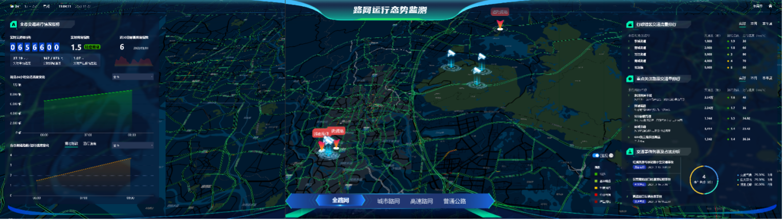
Scenario 1: Road Network Operation Monitoring Platform.
The platform integrates road network information across the entire province, covering all transportation data, and accurately calculates inter-provincial traffic flows (inbound and outbound) as well as passenger and freight vehicle flows, addressing previous inaccuracies in inter-provincial traffic statistics. It enables dynamic monitoring of chartered tourist coaches, intercity coaches, and specialized vehicles for transporting dangerous chemicals, fireworks and explosives across the provincial road network. Based on aggregated and analyzed traffic data, the platform predicts the road network’s operational status for short-term, monthly, quarterly, and annual intervals. By integrating external data sources—such as meteorology, public security, and emergency management—the platform can also monitor and forecast the road network’s carrying capacity in real time, enabling congestion point management, real-time updates on traffic efficiency, major traffic accidents, and blockages at key nodes.
Scenario 2: Transportation Safety Dynamic Monitoring Platform.
This platform conducts dynamic monitoring of the road transport industry, ensuring that safety supervision responsibilities of regulatory authorities and safety production responsibilities of enterprises are effectively implemented. It evaluates “two passenger, one hazardous” transport companies, general freight road transport enterprises, urban public transit, driving schools, and ride-hailing platform companies through assessment scoring. By supervising transport personnel in these enterprises, the platform helps reduce potential road transport safety hazards. Furthermore, by integrating data from national and provincial trunk roads, expressways, and road administration, it reflects the actual operational status of the passenger transport industry from a real-world driving perspective.

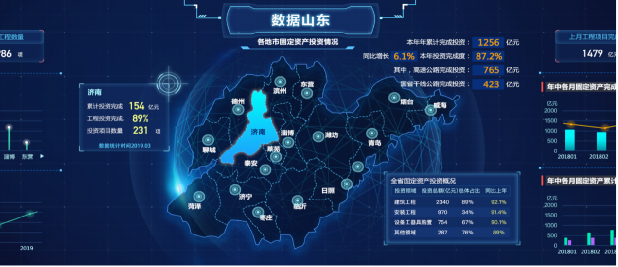
Shandong Provincial Integrated Transportation Management and Service System.
Established a unified and standardized data resource catalog: Integrated and consolidated data from highways, operations, planning, waterways, and law enforcement to build a provincial transportation data resource pool for Shandong.
Initial results achieved in data governance: Sorted out and established a data standards system, promoting high-quality data development.
Developed a data sharing and exchange center: Enabled cross-departmental, cross-sector, and inter-level (ministerial and provincial) data sharing and exchange.
“Data-Driven Shandong” comprehensive visualization: Provides real-time displays of transportation planning, economic performance, infrastructure, and construction investment.
2. Dongguan Smart Transportation
Created a smart transportation demonstration zone by developing the Dongguan Smart Transportation "Cerebellum" and an Integrated Transportation Operation Monitoring and Command & Dispatch Platform.
Promoted Intelligent Urban Traffic Management: Optimized traffic business processes, strengthened interdepartmental collaboration, and improved operational coordination efficiency.
Built a Digital Foundation for Smart Transportation to Support Data-driven Government Decision-making: Connected with more than 60 business systems, integrated and consolidated transportation data, and provided unified support for decision-assistance and analysis.
Created a Benchmark Smart Transportation Demonstration in the Core Area: Established a comprehensive command and control model integrating sensing, management, services, and empowerment to address key issues such as congestion and safety.
Enhanced Public Travel Experience: Improved overall mobility through multi-channel information dissemination and optimization of traffic signal control strategies.
Beijing Address:
Beiming Software Park, 18 Yongyinqu South Road, Shijingshan District, Beijing
Guangzhou Address:
7-8/F, Beiming Software Building, No. 1 Sicheng Road, Tianhe District, Guangzhou


Copyright ©Beiming Software Co., Ltd. All rights reserved. 粤ICP备11034341号
